US Public Lands
- 3.7
- Rating
- 10.00K
- Installs
- $3.99
- Price
 Analysis by App-foxy
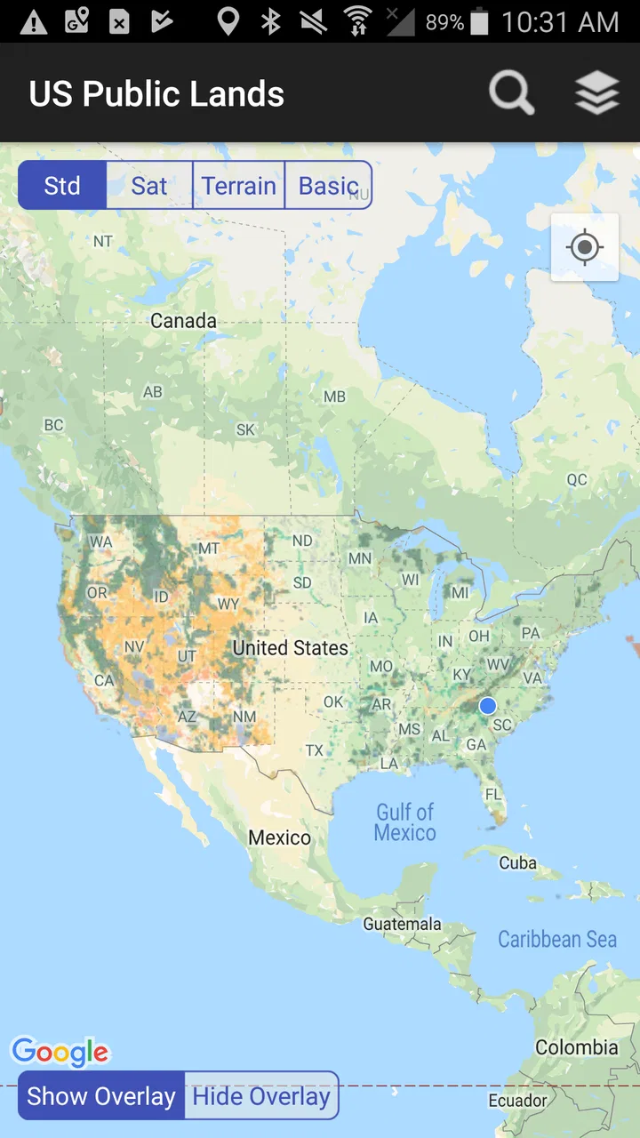
I spend a lot of time planning trips where the important question is not simply “what is nearby?” but “whose land am I actually looking at?” US Public Lands is built for that specific problem. It is a Travel & Local app from Two Steps Beyond LLC that puts public-land boundary maps on a mobile device, making it easier to understand the patchwork of public and private property across the United States.
That focus makes it different from a normal road map or a general hiking app. I would not install it expecting turn-by-turn navigation, a complete trail guide, or a broad travel planner. I see it instead as a boundary-awareness tool: something I would open before choosing a campsite, checking access around a hunting area, planning a backcountry route, or trying to understand why a seemingly open stretch of land may not be legally accessible.
The app costs $3.99, so the value question is straightforward: does a focused map of US public land justify paying for a dedicated tool? In my experience, the answer depends heavily on how often land ownership affects your plans. For an occasional city tourist, probably not. For someone who regularly explores rural areas, the price is easier to justify because one clear boundary view can prevent a great deal of guesswork.
You May Also Like

 Blood Strike: 2.5 Anniversary
Blood Strike’s Loadouts Turn Every Drop Into a Tactical Gamble
A close look at Blood Strike’s custom loadouts: how fast access to signature weapons reshapes its battle royale rhythm, rewards preparation, and narrows the gap between fights.

 Pandora - Music & Podcasts
Pandora’s Music Is Easy to Start, but Harder to Recover
Pandora’s strength is its low-effort path from a seed to a station. Its weak spot is how much confidence it asks you to place in connection, setup, and quiet recovery.

 8 Ball Pool
 Is Built on Rivalries, Rematches, and Routine
A close look at the rivalries, rematches, shared routines, and unanswered safety questions that turn a quick pool match into a persistent mobile community.

 Samsung Music
’s Quiet Strength Is Playing What You Already Own
Its reach comes less from spectacle than from dependable access to a personal library. That simplicity is both the app’s strongest retention engine and its ceiling.

 AccuWeather: Weather Radar
AccuWeather Review: A Quick, Clear Forecast for Everyday Decisions
For everyday plans, the best forecast is the one you can understand quickly. AccuWeather makes rain timing, radar, and local conditions easy to act on, with a few trade-offs.

 Hill Climb Racing
Why Hill Climb Racing Still Turns Crashes Into One More Run
A tiny car, a bumpy hill and one more upgrade: Hill Climb Racing keeps resurfacing because its simple chaos makes every near-miss feel personal.
More From Our News Desk
View All News


How the app fits into real trip planning
When I plan a trip into rural country, I try to check land boundaries before choosing a route, not after I reach a confusing gate or road junction. This section looks at how I’d use the app alongside ordinary navigation and official information, then turns to the practical questions that shape whether it belongs in a trip-planning routine.
A map for ownership context, not a replacement for every map
The most useful way to think about this app is as a layer of context. A conventional map helps me see roads, towns, rivers, and perhaps trails. US Public Lands addresses a different question: whether the surrounding land is part of the public-land network. That distinction matters when a route crosses a confusing mixture of federal, state, and private parcels.
For example, imagine I am driving toward a remote recreation area and notice several access roads branching away from the main route. A standard navigation app may show those roads, but it may not make the ownership pattern obvious. With a public-land boundary map open, I can inspect the surrounding area and form a more informed picture before committing to a turn. That does not automatically grant permission to enter, but it gives me a much better starting point for checking access rules.
I also find the app more useful during the planning stage than while actively traveling. Before leaving home, I can compare a proposed destination with nearby public-land boundaries and identify areas where access may be complicated. This is especially valuable when a route appears simple on a broad map but crosses private property or reaches a public parcel with limited entry points.
Why boundaries are more useful than a generic outdoor label
Many outdoor apps emphasize recreation: trails, campsites, scenic points, or user-submitted locations. Those features are helpful, but they can leave ownership questions in the background. A pin that looks close to a forest or open area does not necessarily tell me whether the route is legal, practical, or open to the public.
This app’s narrow purpose is its strongest advantage. It encourages me to treat land status as part of trip planning rather than as an afterthought. I can use it alongside a trail app, a road-navigation app, or official land-management information instead of asking one application to do everything.
That workflow is one of the less obvious strengths here: I would first use US Public Lands to understand the broad ownership pattern, then switch to a more specialized source for road conditions, closures, trail difficulty, permits, or current regulations. The app becomes the ownership reference in a small toolkit rather than a supposed all-in-one solution.
What the purchase gives me
The verified store information describes the product as an app for viewing US public-land boundary maps on a device. The paid price is $3.99, and that is the clearest basis for judging its value. I am paying for a focused map experience rather than signing up for a general travel service or buying a bundle of unrelated features.
That distinction matters because a low one-time purchase can feel reasonable when the app solves a recurring problem, but it can feel unnecessary when the problem appears only once. If I am planning several trips through rural areas, the ability to consult public-land boundaries repeatedly gives the purchase practical value. If I am taking one ordinary vacation centered on cities and established attractions, I would probably keep using the maps I already have.
I would also avoid assuming that the purchase replaces official confirmation. A map can help me spot the relevant boundary, but access may depend on roads, easements, seasonal restrictions, closures, permits, or rules that are not captured by a simple ownership view. I treat the app as a planning aid, not as legal authorization.
Everyday scenarios where it earns its place
One realistic use is a weekend drive to a dispersed camping area. I might find a promising location through a friend’s recommendation, then use this app to inspect whether the area sits within public land or near a confusing private inholding. If the boundary looks close to the proposed access road, I would use that information to investigate the route more carefully before traveling.
Another scenario involves hunting or fishing preparation. I may know the general region but not understand how public parcels connect. A boundary-focused view can help me identify which areas deserve further research and which apparent shortcuts could create access problems. I would still verify seasons, licenses, local restrictions, and entry rules elsewhere, but the first screening becomes much more efficient.
It can also help when planning photography, wildlife observation, or a long scenic drive. Instead of selecting a destination solely because it appears undeveloped, I can ask whether it is surrounded by public land and whether there are realistic ways to reach it. That extra context can save time and reduce the chance of arriving at a locked gate or an unsuitable access point.
Useful habits for getting more from a boundary map
My first tip is to study the surrounding area, not just the destination pin. A public parcel may look attractive in isolation but be separated from a usable road by private holdings. Looking outward helps reveal whether the location is connected to practical access.
My second tip is to compare several candidate areas before making a final plan. When two destinations offer similar scenery, the one with a simpler public-land pattern may be less stressful and easier to research. This is a better use of the app than opening it only after I have already chosen a campsite.
My third tip is to save the boundary information as part of a broader preparation routine. I would note the relevant area, then separately check current closures, road status, local rules, and weather. The trade-off is a little more preparation, but it prevents the common mistake of treating a public boundary as a guarantee that every approach is available.
A fourth insight is that boundary maps are particularly valuable where ownership changes frequently over short distances. In those places, a broad regional label can be misleading. The app’s usefulness rises as the landscape becomes more fragmented, because that is where ordinary map browsing leaves the most room for error.
Limits I would keep in mind
The focused design also creates limitations. If I want detailed trail descriptions, elevation profiles, live traffic, campsite reservations, social recommendations, or a complete navigation system, this is not the app I would choose as my only travel tool. Its purpose is narrower, and that is both the reason to buy it and the reason not to overexpect from it.
I would also be cautious about interpreting colored areas or boundary lines too confidently without checking the surrounding context. A map display can simplify complicated ownership and access situations. A parcel may be public while the route to it is restricted, or an open-looking road may be unsuitable for my vehicle. The app can highlight the question, but I still need authoritative answers before relying on the plan.
Another practical trade-off is attention. Boundary information is most useful when I have time to inspect it carefully. It is not something I would want to manipulate while driving. I would review the area before departure, keep navigation separate during the trip, and use the boundary map again only when safely stopped.
Compatibility and audience
The current version is 2026.7.0, and the listed minimum operating-system requirement is Android 7.0. That makes the app relevant to people using older compatible Android devices as well as newer phones. The content rating is Everyone, which fits the app’s practical mapping purpose rather than entertainment or mature subject matter.
The app has reached over ten thousand installs and holds a 3.7 average from 123 ratings, with 67 written reviews. Those figures suggest a modest, specialized audience rather than a mass-market travel product. I read that as a sign that the app serves a particular need; I would not judge it by the same expectations I would apply to a major navigation platform.
The developer, Two Steps Beyond LLC, has kept the concept clear: show public-land boundaries in a device-friendly format. That clarity is helpful, but it also means the app’s success depends on whether I personally need that information. A focused tool can be more valuable than a crowded app when its one job matches my planning problem.
Who will get the strongest value
I think the best audience includes campers who explore outside developed campgrounds, hunters and anglers researching unfamiliar regions, photographers seeking remote locations, and road-trippers who frequently pass through rural land. These users are more likely to encounter confusing boundaries and benefit from checking them before making a decision.
It is also a good fit for careful planners who dislike relying on assumptions. If I prefer to understand the land around a destination before setting out, a dedicated public-land view gives me a useful first layer of research. The app is especially sensible when a small purchase can support many future trips rather than just one itinerary.
I would skip it if my travel is mostly urban, resort-based, or limited to well-marked attractions. I would also skip it as a primary choice if I need detailed navigation, live conditions, or recreation discovery in one place. In those cases, a general map or a full outdoor-navigation service is likely to deliver more of what I need, even if its public-land information is less central.
My buy-or-skip verdict
US Public Lands is worth buying when public-land boundaries are a recurring part of your decisions. At $3.99, it asks for a small paid commitment, but the value is not in the number of features. The value is in having a dedicated way to examine ownership context before a rural trip, especially where public and private parcels sit close together.
I would buy it as a companion to my existing travel tools, not as a replacement for them. I would use it to screen destinations, compare access patterns, and identify questions that need official confirmation. That workflow makes the app more useful than simply opening it to admire a map after the trip is already planned.
My final recommendation is therefore conditional but positive. If you regularly camp, hunt, fish, photograph, or travel through less-developed parts of the United States, this focused Travel & Local app can earn its place on your phone. If you want a complete navigation and recreation platform, spend your attention elsewhere. For the right user, the modest paid price buys clarity at exactly the stage when a little extra clarity can make an outdoor plan safer, more realistic, and less frustrating.
FAQs for US Public Lands
01What is US Public Lands, and what can I use the app for?
US Public Lands is designed to help users discover and explore public lands across the United States. It can be useful for researching parks, forests, recreation areas, monuments, and other government-managed locations before planning a trip. Depending on the available data, you may be able to view land details, nearby attractions, access information, and useful planning resources in one place.
02Does US Public Lands provide accurate information about public land boundaries and access?
The app can be a convenient starting point for learning about public lands, but users should not treat it as the only source for legal boundaries, closures, permits, or access restrictions. Public-land information can change because of weather, fire danger, construction, seasonal rules, or management decisions. Before traveling, confirm important details through the relevant official agency or local land-management office.
03Can I use US Public Lands without an internet connection?
Offline availability depends on the app’s current features and the specific information you want to access. Some basic content may be available after it has loaded, but maps, search tools, directions, and updated notices may require an internet connection. If you are visiting remote areas, prepare in advance by saving important information and carrying offline maps, since cellular coverage is often limited or unavailable.
04Is US Public Lands suitable for planning hiking, camping, or outdoor trips?
The app may be helpful during the early planning stages of hiking, camping, sightseeing, and other outdoor activities by helping you identify public destinations and research nearby areas. However, it should be used alongside official regulations, weather forecasts, trail-condition reports, permit requirements, and safety guidance. It may not replace a dedicated navigation app, detailed topographic map, or emergency communication device.
05Is US Public Lands free to download, and are there any privacy considerations?
The download cost and any optional purchases depend on the version available for your Android or iOS device. Before installing, review the store listing for subscriptions, advertising, or paid features. It is also worth checking the app’s privacy disclosures to understand whether it requests location access, stores search activity, or shares information with third parties. Grant only the permissions that are necessary for the features you intend to use.
Pros
- Covers national parks
- forests
- and other public lands across the US.
- Useful maps help identify nearby public land areas while traveling.
- Provides practical information for planning outdoor trips and visits.
- Can help users discover lesser-known recreational destinations.
- Relevant for hikers
- campers
- anglers
- and other outdoor enthusiasts.
Cons
- Coverage and details may vary between different public land agencies.
- Some map features may be limited without an internet connection.
- Information can become outdated when closures or rules change.
- Remote areas may have weak GPS or mobile signal coverage.
- Users may need separate apps for reservations
- permits
- or navigation.

US Public Lands
Gallery